Before the Signpost: How Country Runners Found Their Way
Country running wayfinding combines paper maps, visible landmarks and local knowledge, helping you judge which clue to trust when they do not agree.
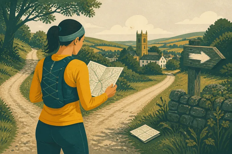
At a fork above a village, a runner finds a folded paper map, a church tower beyond the trees and a hand-painted arrow pointing down the lane. Country running wayfinding is easier when you compare what each clue can tell you, rather than asking one to settle every question.
A map shows how paths and places relate on paper. A landmark helps you relate the map to the view, while local knowledge can explain details that neither makes obvious. Each has limits, so the useful question is not which one is always right, but which one answers the decision in front of you.
What can a landmark tell you that a map cannot?
A bridge, ridge, church tower or distinctive bend in a river can help you recognise the landscape and check your general direction. It gives you something visible to compare with the map, but it may not identify the exact path at your feet.
For example, a tower above the village may confirm that you are heading towards the right settlement. It cannot tell you whether the narrow path or the lane at the next fork is the route you planned. For that, compare the junction’s shape and nearby features with the map.
Use landmarks as reference points, not as instructions to run towards. A line of sight can be blocked by trees, mist or a bend in the ground, and a familiar feature may look different from a new angle.
What does a paper map do better?
A paper map keeps the wider area in view. You can see how paths connect to roads, where streams cross a route and which settlements offer a recognisable reference point. Contour lines also give a sense of the ground’s shape, though they do not tell you exactly how a path will feel underfoot.
Before setting out, mark the route’s important junctions and identify a clear way back towards a familiar place. Check the map’s legend and access guidance, and make sure the route is one you may use. If access rights are unclear, check with the relevant local authority or a knowledgeable local source.
On the run, align the map with the landscape by matching several features, such as a stream, a wood and a road. A phone map can be useful too, particularly if the route is saved for offline use, but keep a paper map if you want a backup that does not rely on a charged phone or signal.
How can local knowledge fill in the gaps?
Someone who knows a district may describe a gate, a lane name or a path that is easy to miss. Those details can make a map easier to interpret, especially where several tracks look alike. Ask for landmarks and the order in which they appear, not just a vague direction such as “over the hill”.
Local directions can also be incomplete or out of date. A gate may have changed, a route may be obstructed, or a name used in conversation may not appear on the map. Treat advice as a clue to check, and follow current access information where it applies.
Say you plan a loop from a village and a resident describes a route past a mill, across a stream and towards a low ridge. You mark those three features on a paper map and see that they appear in the same order; at the mill, the stream crossing is visible, but the path towards the ridge is blocked. The sensible decision is to stop there, avoid the obstruction and use the mapped lane back towards the village rather than assuming the local description still fits.
Which clue should you trust when they disagree?
Compare the clues by asking what each one can confirm. A waymark may point out a turn, a map may show the route’s broader shape and a landmark may confirm your general position. If they conflict, pause somewhere safe and check before choosing a path.
How do I use a landmark without following it blindly?
Pick a distinct feature, such as a bridge or ridge, and use it to check your broad direction. Confirm the actual turn against the map or a clear waymark rather than running towards the feature alone.
What should I do if a map and signpost disagree?
Stop and compare the junction and nearby features with the map. If the route still does not make sense, avoid guessing; retrace the last section you can identify or choose a clear, permitted way back.
Can I rely on local directions for an unfamiliar route?
Use directions to identify useful details, such as a named lane or bridge, then check that they match the map and what you see. If a key detail differs, reassess rather than assuming the route has not changed.
What can I do if I cannot get a phone signal?
Use a paper map or a route saved for offline viewing, and check that you can open the offline information before setting out. If you have neither available, return along a section you recognise instead of relying on a signal appearing.
How do map, landmarks and local knowledge work together?
Use the map to understand the route’s shape, landmarks to check how that shape sits in the landscape, and local knowledge to interpret details that remain unclear. These tools are not interchangeable: a tower cannot show a hidden junction, and a local name cannot establish whether a path is open to you.
When the clues agree, you can make the next turn with a clearer picture of where it leads. When they do not, look for the point where they last agreed. That gives you a known place to reconsider the route rather than building a new guess on top of an uncertain one.
- Check whether the map shows the same junction shape you can see; if it matches, follow the planned turn, but if it does not, pause and compare nearby features.
- Check whether a landmark is distinct and visible; if it confirms your general direction, use it as a reference, but if it is hidden or ambiguous, use the map and closer features instead.
- Check whether a waymark points along the route shown on your map; if both agree, continue, but if they conflict, stop and inspect the junction before choosing.
- Check whether local directions name a bridge, lane or gate that matches the map; if the details agree, use them to identify the route, but if one is missing or changed, reassess the advice.
- Check whether the path ahead is open and permitted; if it is, continue on the planned route, but if it is blocked or access is uncertain, use a permitted alternative or retrace your steps.
- Check whether your phone map is available offline and has enough charge for the run; if it does, keep it as a useful aid, but if not, use a paper map or choose a familiar route.
What should you do when the clues stop agreeing?
Pause somewhere safe and identify the last point where the map, landscape or directions made sense. Compare the next junction with the map, checking the arrangement of paths, water, buildings and roads rather than relying on one isolated detail.
If you cannot establish where you are, retrace the known section or use a clear, permitted route towards a familiar place. Country running wayfinding works best when you let the evidence in front of you shape the next decision; carrying a map and noting a few reliable landmarks before you leave makes that decision easier.