Why Field Edges Make Such Clear Route Lines
Field edges make clear route lines by revealing how fields are divided and managed, helping you read the countryside without mistaking a boundary for access.
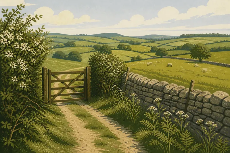
A hawthorn hedge parts at a farm gate, while the next field is bordered by a dry-stone wall. On a countryside run, field edges make clear route lines because they show how the land is divided, even when the public path itself is faint.
That distinction matters. A boundary can help you read the shape and use of the landscape, but it does not automatically mark a path or give permission to cross. Think of it as information about the field, not an invitation to enter it.
What can a field boundary tell you?
Field boundaries are clues to how land has been divided and managed. A hedge may separate pasture from a lane, a wall may enclose grazing land, and a ditch may mark a low or wet edge. Their materials and placement give the landscape a structure you can recognise as you move through it.
Notice the character of an edge: clipped or overgrown, continuous or broken, sharply built or softened by vegetation. These details can help distinguish one section of countryside from another, without assuming that the boundary itself determines where a public route runs.
Boundaries also affect what you can see. A tall hedge can screen a field; a low wall may offer a view across it; a tree-lined bank can make an edge visible from a distance. The changing view is useful context, but it is not evidence that a gap or crossing is open to runners.
How do hedges, walls and ditches differ?
Hedges are living boundaries, often made from a mix of shrubs and trees. Their shape can vary with cutting and growth, and their roots may sit on a raised bank or beside a ditch. A gap might be a field entrance, a footpath crossing or simply a break in the vegetation, so its appearance alone does not settle which.
Stone walls have a more defined outline, and their construction can vary from carefully laid courses to rough piles of local stone. A wall may be intact, partly collapsed or hidden by brambles. Even a low or damaged section remains a boundary, not an invitation to climb over it.
Ditches and banks can be less obvious, especially under grass or leaves. They may run alongside a hedge or wall, or form an edge on their own. Watch your footing near them, particularly when the ground is wet, and avoid stepping onto an unstable bank to get a better view.
Why do field edges change from place to place?
Some boundaries reflect long-standing patterns of farming; others have been altered as fields are combined, divided or brought into different use. In one area, hedges may enclose small fields. Elsewhere, a wall, fence or drainage ditch may be the most visible edge.
Land management changes how a boundary looks through the seasons. New growth can soften a wall’s outline, while cutting can make a hedge look suddenly lower. A recently worked field may leave a muddy margin or exposed soil beside the edge. Treat these as changes in appearance, not proof that a route or access arrangement has changed.
When several kinds of boundary meet, look at how they connect: perhaps a hedge ends at a wall, or a ditch follows a fence for part of its length. The junction can reveal how the parcels of land fit together, even if you cannot see what lies beyond the next field.
How can field edges help you read the landscape?
Use boundaries to describe what surrounds you rather than to choose where to run. For instance, “narrow lane beside a tall hedge, then open pasture beyond a wall” gives you a clear picture of the landscape. It keeps observation separate from access decisions.
Imagine you are running on a public footpath shown on your map, alongside a hedge and a drainage ditch. At a bend, the hedge ends at a wooden fence, and a broad gap appears to lead into the next field. You note the change from hedge to fence, check the mapped path and follow its marked line rather than crossing through the gap; the result is a more accurate description of the landscape and no assumption about the opening.
When you pass a field edge, notice what changes on either side: the surface, vegetation, slope or view. A grassy strip beside a hedge may feel different underfoot from a rutted track beside a wall. These contrasts can help you understand the terrain without treating the boundary as the route.
What field-boundary questions do runners ask?
Does a hedge mean there is a footpath beside it?
No. A hedge may mark the edge of private land, and a public path may be beside it, cross it elsewhere or not be there at all. Check the route and access information rather than inferring permission from the hedge.
Why are some field boundaries hard to see?
Vegetation, shadow, weather and the shape of the ground can hide or soften an edge. A ditch may be covered by grass, while a wall can disappear behind brambles or overhanging branches.
Can I cross a damaged wall or open gap?
Not simply because it looks passable. Use a crossing only when it is part of the public route or access is otherwise permitted; if that is unclear, stay on the route you are authorised to use.
What should I notice when a boundary changes?
Look for the point where one material or form gives way to another, such as hedge to fence or wall to ditch. That change helps you describe the field pattern, but it does not by itself indicate a junction or a route.
How can you observe boundaries without confusing them with access?
Keep two questions separate: “What kind of edge is this?” and “Where am I allowed to run?” The first is a landscape observation; the second depends on public rights of way and access rules. A gate, stile or gap can be part of a route, but its presence alone does not establish that.
On a run, you might quietly note “stone wall, wet ditch, hedge with a wide opening” and keep moving along the path you are entitled to use. That simple habit makes field edges easier to read while keeping your decisions about access grounded in the route information, not the appearance of the boundary.
Field edges make clear route lines in the landscape because they show where one parcel of ground meets another. The next time a hedge gives way to a wall or ditch, notice what changes in the view and underfoot—and let the boundary describe the land rather than decide your route.